Ces quatre dernières semaines ont été marquées par des épisodes méditerranéens répétitifs, en particulier sur l’Hérault et le Gard. Si une telle fréquence est rare, elle n’est pas inédite. Les automnes 2010, 2005, 2003, 2002, 1995, 1993 etc… avaient aussi connu des épisodes de ce type à plusieurs reprises.

Pourquoi ces phénomènes de fortes pluies à répétition ? A cause d’une anomalie synoptique qui peut se produire parfois : un anticyclone bloqué sur l’est de l’Europe et des basses pressions qui s’étalent des îles Britanniques à la péninsule Ibérique. Entre les deux, un flux de sud-ouest chaud et humide s’engouffre sur la Méditerranée surchauffée à la sortie de l’été, se chargeant encore en humidité. Le vent marin fait le reste en dirigeant toute cette humidité vers le golfe du Lion. Arrivés en butée sur les reliefs, les nuages se bloquent et déversent des quantités d’eau parfois incroyables. Ce phénomène existe depuis toujours !
L’épisode pluvieux du 16 au 18 septembre a donné jusqu’à 468 mm à Saint-Gervais-sur-Mare (Hérault), ce qui représente 40% du quota… annuel de précipitations !
Le 29 septembre, il est tombé 299 mm de précipitations à Montpellier où de graves inondations se sont produites.
Dans la nuit du 6 au 7 octobre, la station de Prades-le-Lez, à quelques kilomètres au nord de Montpellier, a mesuré 262 mm de précipitations.
Quant au dernier épisode cévenol du 9 au 13 octobre, il a provoqué jusqu’à 559 mm à Barnas (07), dont 310 mm pour la seule journée de dimanche.
Bien que durable, ce dernier épisode n’a pas provoqué les conséquences désastreuses attendues quelques jours auparavant. Moins étendu que prévu géographiquement parlant, il s’est surtout cantonné aux Cévennes. Les crues et inondations ont donc été relativement « modérées ».
Rappelons que le record national de précipitations en 24 heures est de 1000 mm (1 mètre) le 17 octobre 1940 à Saint-Laurent-de-Cerdans (Pyrénées-Orientales). Il était alors tombé 1930 mm en 5 jours du 16 au 20 !
Au cours de ce début de mois d’octobre perturbé, c’est bien sur les Cévennes qu’il a le plus plu (plus de 500 mm de cumul localement). Mais d’autres régions ont été largement arrosées : le Lyonnais, le Jura, la Bourgogne, le Centre, le Limousin, l’ouest des Pays de la Loire, le Morbihan et le Finistère.
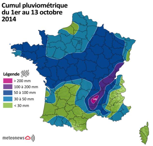
Fig. 1
Peu de pluie en revanche de l’Aquitaine au littoral languedocien ainsi qu’en Corse.
Des nouveaux passages pluvieux vont traverser la France d’ici jeudi avant une poussée anticyclonique le week-end prochain. Le pourtour méditerranéen va retrouver des conditions météo beaucoup plus calmes et sèches. Mais l’automne n’est pas terminé : des nouveaux épisodes méditerranéens sont susceptibles de revenir d’ici fin novembre, voire début décembre.