Alors qu'on ne puisse pas dire qu'on ait été particulièrement gâtés ces derniers jours en France, entre fraîcheur résiduelle et déjà des orages par endroits, le temps va plus franchement encore se dégrader à partir de ce jeudi après-midi sur la façade Ouest, puis demain vendredi notamment sur le Languedoc-Roussillon où on attend des pluies cévenoles très abondantes. Stéphane Nedeljkovitch de MeteoNews fait le point dans ce bulletin.

La situation n'était pourtant déjà pas fameuse sur le pays depuis plusieurs jours, entre fraîcheur relative au Nord (à peine plus de la vingtaine de degrés), et des orages localement forts au Sud (notamment près des reliefs), mais le temps va connaître une évolution rapide dès ce jeudi. Un léger flux de sud va en effet nous ramener une chaleur brutale cet après-midi, avec des pointes proches des 26 à 32 degrés au Nord comme au Sud. A titre d'exemple, on attend en effet 29 ou 30 degrés dans la capitale ce jeudi, alors qu'il n'en faisait même pas 25 mercredi, et 21 les jours précédents. Et cette chaleur sera d'ailleurs assez homogène, avec 27 ou 28 degrés prévus à Metz, 30 à 32 degrés de Dijon à Lyon et Avignon, et 28 à 30 degrés en Aquitaine. En revanche, qui dit chaleur brutale, rime souvent avec dégradation orageuse. Et ces orages ne manqueront pas en effet de se développer dès le milieu de cet après-midi de jeudi, d'abord sur la Bretagne et l'Aquitaine, puis de nouveau de l'Aquitaine, à l'ouest de Midi-Pyrénées, au Poitou, aux Pays de la Loire, à une partie du Centre et à la Basse-Normandie (voire plus localement sur la Haute-Normandie et l'ouest de l'Ile-de-France) en fin de journée ou soirée. C'est à ce moment là que ces orages seront ponctuellement violents, accompagnés de lames d'eau importantes, parfois 20 ou 30 litres d'eau voire plus en quelques heures à peine. La grêle sera aussi localement au rendez-vous, sans oublier de fortes rafales de vent, soit le cocktail habituel des orages.
Puis cette situation très instable se poursuivra demain vendredi, tout en se décalant plutôt entre Midi-Pyrénées et le Languedoc-Roussillon dès le matin, avec des pluies parfois torrentielles et continues une bonne partie de la journée. On attend en effet des cumuls pluviométriques voisins de 100 litres d'eau ou plus dans la journée, et particulièrement sur le Gard et l'Hérault, voire sur la Lozère et l'Ardèche jusqu'en soirée de vendredi. Les Bouches-du-Rhône et le Vaucluse seront aussi très fortement arrosés. Ces pluies pourront engendrer des inondations partielles ou localement majeures sous les plus fortes intensités, soyez extrêmement prudents sur ces régions méridionales.
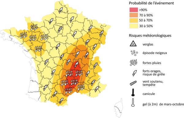
Fig. 1
Par ailleurs les averses orageuses seront encore d'actualité sur une bonne partie de la France pour vendredi, mais avec une intensité plus modérée. La suite s'annonce encore très instable jusqu'au week-end voire à lundi, avec des pluies souvent accompagnées d'orages sur les deux-tiers Sud. Une amélioration est attendue pour le milieu de semaine prochaine avec le retour de l'anticyclone a priori.