Un blocage anticyclonique va s’imposer ces prochains jours et la semaine prochaine entre le Maghreb et la France, apportant des conditions sèches, ensoleillées mais surtout très chaudes. En effet, le flux va basculer plein Sud, apportant une masse sub-tropicale en provenance du Sahara. Des températures caniculaires seront donc à attendre, notamment en milieu de semaine prochaine où la barre des 40 degrés pourrait être atteinte, notamment en Aquitaine, selon Pierre-Antoine Dutheil et Christophe Mertz de MeteoNews.

Arrivée des très fortes chaleurs dès mardi
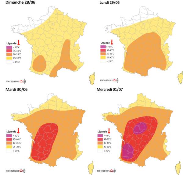
Fig. 1
Les conditions s’annonceront anticycloniques et très ensoleillées entre ce dimanche 28 juin et mercredi voire jeudi 1er et 2 juillet, avec beaucoup de soleil sur l’ensemble de l’hexagone et une chaleur qui va s’accentuer de jour en jour. Les températures atteindront d'abord progressivement les 24 à 27 degrés sur la moitié Nord, localement 29 degrés dimanche et lundi tandis qu’elles dépasseront déjà souvent les 30 degrés dans la moitié Sud, notamment en Aquitaine et en Méditerranée avec des pointes à 35 degrés, principalement dans le Vaucluse et le Gard.
Mardi, la masse d’air se réchauffera encore un peu plus et les 30 degrés seront fréquemment atteints dans la moitié Nord, localement 32 à 34 degrés entre la Bourgogne et la région Centre. Plus au Sud, la chaleur deviendra torride avec des valeurs souvent comprises entre 33 et 35 degrés. Localement, des pointes à 40 degrés pourront être observées en Aquitaine. Le pic de chaleur devrait être atteint mercredi sur le pays. En effet, le mercure devrait atteindre aisément les 32 à 35 degrés sur la moitié Nord et dans l’Est du pays tandis qu’il devrait afficher les 38 à 40 degrés de l’Aquitaine aux Charentes et à la région Centre en passant par les plaines auvergnates.
Des températures nocturnes élevées en ville
Par ailleurs, les températures baisseront peu les nuits, affichant de 15 à 18 degrés sur la moitié Nord et de 19 à 21 voire 22 degrés dans le Sud-Ouest, le long de la vallée du Rhône ou encore vers le Dijonnais et à Paris intra-muros. La masse d’air pourrait également se déstabiliser sur la façade atlantique jeudi avec l’arrivée d’orages, repoussant progressivement les températures les plus caniculaires vers l'Est sans toutefois marquer la fin définitive de cet épisode, qui pourrait bien persister jusqu'au week-end.
Des records approchés ou battus ?
Cette vague de chaleur pourrait bien apporter de nouveaux records, notamment entre le Sud-Ouest et le Centre du pays où les températures seront le plus susceptibles d’atteindre les 40 degrés. Quelques records d’antan :
- 41,2°C à Mont-de-Marsan (40) le 26 juillet 1947 et à Vichy (03) le 31 juillet 1983
- 40,8°C à Dax (40) le 8 juillet 1982
- 40,6°C à Agen (47) le 12 juillet 1949
- 40,2°C à Châteauroux (36) le 28 juillet 1947
- 40,1°C à Cognac (16) le 12 juillet 1949
- 39,8°C à Cazaux (33) le 8 juillet 1982
- 39,6°C à Bourges (18) le 28 juillet 1947
- 39,2°C à Bergerac (24) le 8 juillet 1982
- 37,9°C à Romorantin (41) le 17 juillet 1964
Durant cette période caniculaire, MeteoNews vous donne quelques conseils :
- pensez à bien vous hydrater
- éviter de sortir aux heures les plus chaudes ou de pratiquer une activité sportive intense
- maintenez votre logement au frais
- rafraîchissez-vous et mouillez-vous le corps plusieurs fois par jour
- passez si possible 2 à 3 heures par jour dans un endroit frais


